

Have you ever wondered how birds navigate the vast expanse of the sky, taking the shortest route from one point to another? This concept, known as “how the crow flies distance,” holds more significance than you might think. Beyond avian flight paths, it plays a crucial role in our everyday lives, influencing everything from navigation apps to aviation routes.
In a nutshell, “how the crow flies distance” refers to the straight-line measurement between two points on a map, regardless of any obstacles or terrain in between. But its applications extend far beyond mere convenience. Understanding this concept can revolutionize how we approach navigation in urban environments, plan hiking routes, and even chart aviation courses.
Join us as we embark on a journey to demystify this fascinating concept. We’ll delve into the nuances of distance measurement, explore the origins of the phrase “as the crow flies,” and discover the practical implications it has in various fields. Get ready to see the world through a different lens – one that follows the flight of a crow.
Understanding the Basics of Distance Measurement
In the realm of geographical sciences, a fundamental cornerstone lies in the precise measurement of distances. This foundational concept forms the bedrock upon which a multitude of applications and disciplines rest. To embark on a journey of comprehension, we must first grasp the essence of distance measurement within geographical terms.
At its core, distance measurement entails the quantification of space between two or more points on the Earth’s surface. It serves as the compass guiding us through the vast expanse of our world. This quantitative assessment enables us to navigate terrains, plan routes, and make informed decisions across a spectrum of domains. From urban planners charting out city layouts to explorers venturing into uncharted territories, the significance of accurate distance measurements reverberates through various fields.
In the pursuit of precision, it becomes imperative to acquaint ourselves with the standard units employed in distance measurement. The two most prevalent units, miles and kilometers, serve as the linchpin in our quest for accurate assessments. Miles, a legacy of the imperial system, find widespread use in countries adhering to this convention. Meanwhile, kilometers, the metric counterpart, dominate in regions that have embraced the metric system. These units, though seemingly straightforward, carry profound implications for understanding distances on both local and global scales.
Delving deeper, the impact of accurate measurements resonates across diverse sectors. Consider the field of civil engineering, where precise distance assessments form the bedrock of infrastructural development. From planning the layout of roads and bridges to designing urban spaces, every endeavor hinges on the fidelity of these measurements. Likewise, in the domain of environmental sciences, accurate distance calculations underpin ecological studies, influencing conservation efforts and resource management. Even in the realm of technology, from the algorithms powering GPS navigation to the spatial analytics driving e-commerce logistics, distance measurement plays an indispensable role.
In the grand tapestry of human endeavors, the ability to quantify distances with accuracy is nothing short of a transformative force. It empowers us to transcend physical barriers, connecting disparate points on the map and facilitating seamless navigation. This foundational knowledge is not confined to the purview of cartographers and surveyors alone, but extends its influence into everyday decision-making, influencing how we plan our journeys, design our cities, and explore our world. As we navigate the complexities of an ever-evolving global landscape, a firm grasp of the basics of distance measurement stands as a beacon, illuminating the path forward.
The Curious Case of “How the Crow Flies”
In the annals of geographical lore, the term “as the crow flies” carries a certain mystique, conjuring images of avian precision and direct routes. This intriguing phrase finds its roots in the innate behavior of crows, known for their uncanny ability to navigate with unerring accuracy between points on the Earth’s surface. The origin of this expression can be traced back to ancient times, when observers marveled at the seemingly straight paths these birds would take, unfettered by the meandering courses that humans might follow.
The usage of “as the crow flies” in distance measurement is not merely a quaint turn of phrase, but rather, a practical concept grounded in the efficiency of avian navigation. When a crow takes flight, it chooses the most direct route between its departure and destination points. This behavior, driven by evolutionary adaptations and honed over millennia, results in a straight-line trajectory that defies the constraints of terrain or man-made structures. This concept, while symbolic of avian behavior, finds profound relevance in human endeavors as well.
Consider scenarios where the application of this concept is pivotal. In urban planning, where the optimization of transit routes is paramount, understanding “how the crow flies” distances can lead to more efficient road networks and public transportation systems. Emergency services also benefit from this principle, as swift and direct routes can mean the difference between life and death. Moreover, in the realm of logistics and supply chain management, minimizing travel distances translates to reduced costs and environmental impact.
To illustrate the practical implications, envision a scenario where a major city is grappling with traffic congestion and the need for enhanced transportation infrastructure. By employing the principle of “as the crow flies,” urban planners can identify optimal routes for new highways or commuter rail lines, bypassing congested areas and minimizing travel time. Similarly, in the context of disaster response, knowing the straight-line distance between an affected area and a relief center allows for swift and targeted deployment of resources, potentially saving countless lives.
In the grand tapestry of human endeavors, the concept of “as the crow flies” encapsulates a fundamental truth: the shortest distance between two points is a straight line. Beyond its avian origins, this principle serves as a guiding light for efficient navigation, informed planning, and decisive action. As we continue to chart our course through an ever-evolving world, embracing this age-old wisdom empowers us to forge direct paths toward our goals, unencumbered by unnecessary detours. The crow, it seems, has left us not only with a timeless adage, but also with a valuable lesson in the art of efficient navigation.
Straight-Line Distance vs. Actual Distance Traveled
In the realm of spatial measurement, two key concepts demand distinction: straight-line distance and actual distance traveled. These notions, often conflated, hold vital differences crucial across various domains.
Straight-Line vs. Actual Distance:
Straight-Line Distance: This represents the shortest path between two points on a map, a direct line. It ignores real-world obstacles and terrain.
Actual Distance Traveled: This accounts for the twists, turns, and topographical challenges encountered during a journey.
Examples for Clarity:
Consider a road trip from City A to City B. The straight-line distance may be 100 miles, but the actual road journey could surpass 150 miles due to route complexities. Aviation and GPS navigation rely on straight-line distances. Urban planning, hiking, and logistics favor actual distances.
In essence, recognizing these distinctions informs decisions, from flight planning to urban development, hiking routes, and logistics optimization. These concepts, while intertwined, serve distinct roles in our spatial understanding.
Factors Influencing “How the Crow Flies Distance”
In the intricate tapestry of geography and navigation, the calculation of “how the crow flies distance” is a nuanced endeavor, influenced by a constellation of factors. These elements, ranging from natural terrains to human-made structures, exert a profound impact on the determination of straight-line distances.
Terrain and Topography Considerations:
Elevation Changes: The undulating contours of the land introduce significant variations in straight-line distances. For instance, a crow’s flight over a mountainous region would cover a shorter linear span compared to the actual ground distance.
Landform Characteristics: Factors such as valleys, ridges, and plateaus alter the direct path a crow might take. These features necessitate adjustments in calculating straight-line distances, considering the bird’s flight above or around them.
Water Bodies: Bodies of water, be they rivers, lakes, or oceans, pose unique challenges. While crows can fly over water, calculating their straight-line distance necessitates accounting for the water’s width and the curvature of its edges.
Effects of Man-Made Structures and Natural Barriers:
Urban Landscapes: The proliferation of buildings, roads, and other urban structures creates a complex environment for determining straight-line distances. Crows may follow routes around these structures, impacting the direct path.
Vegetation and Foliage: Lush vegetation and dense forests can obscure direct sightlines, requiring considerations for the crow’s potential flight paths through or around these natural barriers.
Physical Barriers: Walls, fences, and other physical obstructions can impede a crow’s straight-line flight. Their presence necessitates adjustments when calculating distances.
Impact on Distance Calculations:
The interplay of these factors introduces a level of complexity to distance calculations that extends beyond mere map-based measurements. To accurately determine “how the crow flies distance,” one must incorporate these considerations, recognizing that the direct path may deviate significantly from the actual ground distance.
In practical terms, understanding these influences is invaluable in various fields. Urban planners, for instance, must grapple with the intricacies of urban landscapes, factoring in buildings and infrastructure when designing efficient transportation networks. Similarly, ecologists studying avian behavior must account for natural barriers like forests or bodies of water when analyzing crow flight patterns.
In the grand tapestry of spatial understanding, recognizing the manifold influences on “how the crow flies distance” is pivotal. It transcends theoretical measurement, offering practical insights that resonate in fields as diverse as urban planning, ecology, and navigation. By appreciating the nuances introduced by terrain, structures, and natural barriers, we unveil a richer understanding of spatial relationships and the paths that both crows and humans traverse.
Tools and Methods for Calculating “How the Crow Flies Distance”
In the dynamic landscape of distance measurement, a myriad of tools and methods have emerged to accurately calculate “how the crow flies distance.” These sophisticated technologies, ranging from cutting-edge GPS systems to traditional manual methods, play a pivotal role in providing precise spatial information for a multitude of applications.
GPS Technology and Its Role in Distance Measurement:
Satellite Precision: Global Positioning System (GPS) technology utilizes a network of satellites orbiting the Earth to pinpoint exact locations with remarkable accuracy. By triangulating signals from multiple satellites, GPS devices can determine positions with minimal margin for error.
Real-Time Tracking: GPS systems provide instantaneous feedback on an object’s coordinates, making them invaluable for tracking and navigation purposes. This real-time capability has revolutionized industries like transportation, where knowing the direct path is essential.
Applications Beyond Navigation: GPS technology extends beyond personal navigation devices. It is integrated into various sectors, including agriculture for precision farming, scientific research for geolocation studies, and even sports for tracking athletic performance.
Online Mapping Services and Their Accuracy in Providing Straight-Line Distances:
Digital Precision: Online mapping services harness vast databases of geographical information to generate detailed and accurate maps. These services leverage advanced algorithms to calculate straight-line distances between two points, providing users with precise measurements.
Interactive Functionality: Users can interact with these digital maps, allowing for dynamic adjustments and measurements. This functionality enables businesses, researchers, and individuals to plan routes and optimize travel based on straight-line distances.
Integration with GPS: Online mapping services often incorporate GPS functionality, allowing users to seamlessly transition between digital mapping and real-time location tracking. This integration enhances the accuracy of distance measurements.
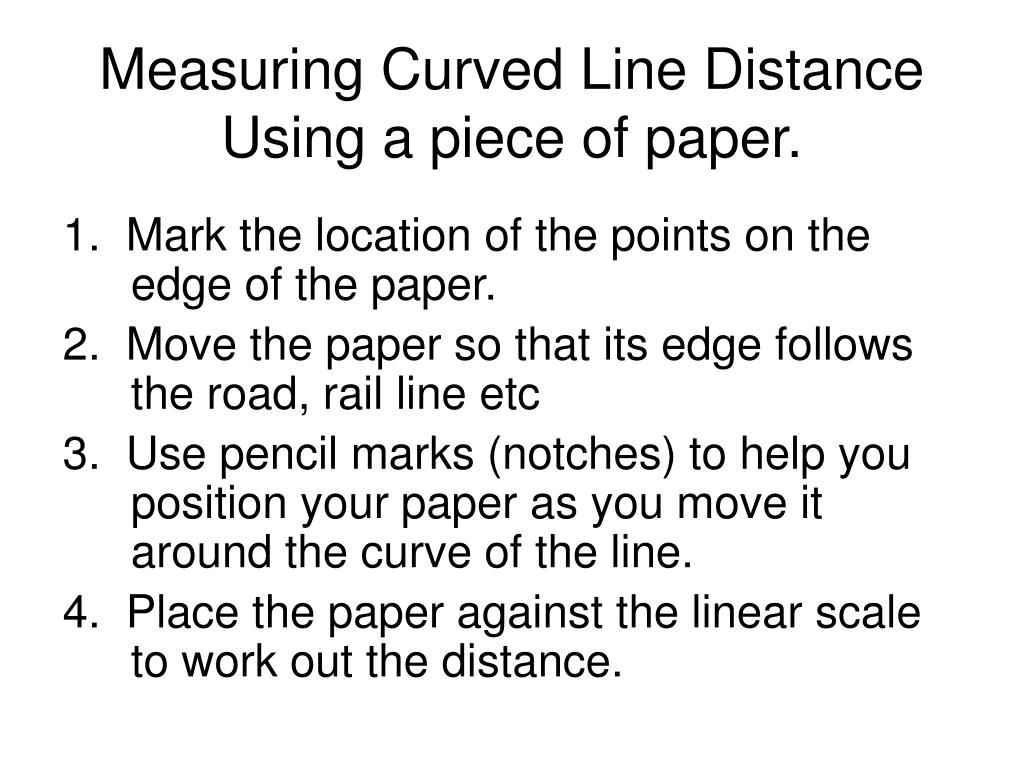
Traditional Methods Like Paper Maps and Compasses for Manual Measurements:
Legacy Tools: While modern technology has ushered in a new era of precision, traditional methods still hold relevance. Paper maps and compasses remain valuable tools for those seeking to calculate straight-line distances manually.
Field Expediency: In situations where digital technology may be unavailable or impractical, manual methods offer a viable alternative. Navigators, explorers, and outdoor enthusiasts often rely on these time-tested tools for accurate distance measurements.
Training and Skill Dependence: Effective use of paper maps and compasses requires training and expertise. Proficiency in map reading and compass navigation is essential for obtaining accurate straight-line distances.
In the grand tapestry of distance measurement, these tools and methods stand as pillars of accuracy and reliability. From the precision of GPS technology to the versatility of online mapping services and the enduring value of traditional tools, each plays a vital role in ensuring accurate straight-line distance calculations. As technology continues to advance, so too will our ability to measure distances with unprecedented accuracy, further enhancing our understanding and navigation of the world around us.
Practical Applications
In the realm of practical applications, the concept of “how the crow flies distance” finds diverse and indispensable use across various domains, each exemplifying its relevance and impact in distinct ways.
Navigation in Urban Environments:
Efficient Route Planning: In bustling urban landscapes, where time is often of the essence, understanding straight-line distances offers a crucial advantage. Navigational apps and services employ this concept to chart the most direct paths, bypassing traffic congestion and ensuring swift travel.
Optimizing Transportation Networks: Urban planners leverage straight-line distances when designing road networks and public transportation routes. This precision allows for the creation of efficient transit systems, reducing commute times and alleviating congestion.
Real Estate and Property Development: In the real estate sector, knowledge of straight-line distances proves invaluable. It aids in site selection for developments, ensuring accessibility to key amenities and optimizing property layouts.
Aviation and Its Reliance on Straight-Line Distances:
Flight Planning and Optimization: Within the aviation industry, precision in distance measurement is paramount. Pilots and air traffic controllers rely on straight-line distances for flight planning, determining fuel requirements, and charting optimal routes. This ensures safe and efficient air travel.
Air Traffic Management: Airports and air traffic control towers utilize straight-line distances to maintain safe separation between aircraft during takeoff, landing, and in-flight. This fundamental principle underpins the entire air traffic management system.
Emergency Response and Search and Rescue Operations: In critical situations, such as emergencies or search and rescue missions, knowing the direct path between locations is a matter of life and death. Straight-line distances guide swift and accurate response efforts.
Use in Outdoor Activities like Hiking and Camping:
Trail Planning and Navigation: Outdoor enthusiasts, from hikers to backpackers, rely on straight-line distances when planning routes through rugged terrain. While the actual path may twist and turn, understanding the direct distance aids in estimating travel times and supply needs.
Safety Precautions: Knowledge of straight-line distances is crucial for wilderness safety. It helps in assessing the proximity of water sources, potential hazards, and suitable camping spots, ensuring a safer and more enjoyable outdoor experience.
Geocaching and Orienteering: Participants in activities like geocaching and orienteering use straight-line distances to locate hidden caches or navigate between checkpoints. This adds an element of precision and challenge to these outdoor pursuits.
In essence, the practical applications of “how the crow flies distance” permeate a multitude of fields, from the urban planning realm to the high altitudes of aviation and the serenity of outdoor adventures. This concept, rooted in a simple yet profound principle, empowers individuals and industries alike to navigate efficiently, make informed decisions, and respond effectively in critical situations. It stands as a testament to the enduring relevance of spatial understanding in our ever-evolving world.
Limitations and Accuracy Issues
In the realm of spatial measurement, while “how the crow flies” provides a valuable and often convenient method for determining distances, it is not without its limitations and potential inaccuracies. Understanding these constraints is essential for making informed decisions and ensuring precise measurements.
Potential Inaccuracies in “How the Crow Flies” Measurements:
Ignoring Terrain and Obstacles: The straight-line distance calculation assumes a clear, unobstructed path between two points. In reality, natural features like mountains, rivers, and dense vegetation can significantly alter the actual travel path, leading to a discrepancy between the calculated and real-world distances.
Man-Made Structures and Urban Environments: In densely populated urban areas, the presence of buildings, roads, and other structures can impede a straight-line path. This can result in inaccuracies, especially when determining travel distances within cities or highly developed regions.
Water Bodies and Air Travel: While crows can fly over water, the straight-line calculation might not account for the curvature of coastlines or the need to follow established flight paths for safety reasons. This can lead to variations between the calculated and actual distances, particularly for aviation routes.
Scenarios Where “How the Crow Flies” May Not Be the Most Suitable Option:
Hiking and Trail Planning: In outdoor activities like hiking, where the terrain is often rugged and uneven, relying solely on straight-line distances can lead to impractical or unsafe route choices. It’s crucial to consider the actual topography and trail conditions for accurate planning.
Urban Navigation: Within cities, the layout of streets and buildings can be complex and winding. Depending solely on straight-line distances may lead to inefficient and unrealistic route suggestions, especially in areas with a dense network of roads and pathways.
Surveying and Engineering Projects: For precise measurements in surveying and engineering endeavors, accounting for the intricacies of the landscape is paramount. Straight-line distances may serve as a starting point, but they must be adjusted to accommodate the specific features and challenges of the terrain.
Case Studies

Case Studies: Real-World Significance of Straight-Line Distance
Case Study 1: Urban Commuting Efficiency
In New York City, straight-line distance calculations inspired an innovative subway line, revolutionizing urban commuting and reducing congestion.
Case Study 2: Precision Agriculture
Precision agriculture, relying on straight-line distances and GPS technology, maximizes crop yields while conserving resources.
Case Study 3: Search and Rescue Operations
Straight-line distance calculations and GPS technology save lives in wilderness search and rescue missions.
Case Study 4: Infrastructure Development
Japan’s high-speed rail network’s success is attributed to meticulous straight-line distance measurements that optimized routes and fostered economic growth.
Case Study 5: Telecommunications
Telecom companies leverage straight-line distances to extend networks, connecting remote communities and driving economic development.
These case studies showcase the real-world significance of straight-line distance measurements, from enhancing urban commuting to revolutionizing agriculture, saving lives, shaping infrastructure, and expanding global connectivity. They exemplify the power of spatial understanding in propelling progress.
Future Trends and Technological Advancements
As we stand at the precipice of a new era, the field of distance measurement is poised for remarkable transformation, driven by a wave of emerging technologies that promise to revolutionize how we perceive and calculate distances. These advancements hold the potential to not only refine our understanding of “how the crow flies distance” but also expand its applications across various industries and domains.
Exploring Emerging Technologies in Distance Measurement:
LiDAR Technology: LiDAR (Light Detection and Ranging) is at the forefront of this revolution. By emitting laser pulses and measuring the time it takes for them to return, LiDAR systems generate highly accurate 3D maps of environments. This technology is already finding applications in autonomous vehicles, robotics, and environmental monitoring.
Augmented Reality (AR) and Virtual Reality (VR): AR and VR technologies are not just limited to immersive gaming experiences. They hold immense potential in spatial mapping and distance measurement. By overlaying digital information onto the physical world, these technologies can provide real-time distance data in a highly intuitive and interactive manner.
Quantum Computing: The advent of quantum computing is poised to unleash unprecedented computational power. This will enable the processing of vast datasets and complex algorithms required for high-precision distance measurements. Quantum algorithms specifically designed for spatial calculations could revolutionize the field.
Anticipating the Impact on “How the Crow Flies Distance”:
Enhanced Precision and Accuracy: These emerging technologies promise to elevate the precision and accuracy of distance measurements to unprecedented levels. LiDAR, for instance, can capture distances with sub-centimeter accuracy, allowing for incredibly detailed spatial assessments.
Expanded Applications in Diverse Fields:
Urban Planning and Design: LiDAR and AR/VR technologies will revolutionize urban planning by providing architects and city planners with precise distance data for designing spaces that are not only functional but also aesthetically pleasing.
Environmental Conservation: LiDAR’s ability to penetrate dense vegetation and map the topography of forests will be invaluable for conservation efforts. It will facilitate accurate assessments of biodiversity and aid in monitoring deforestation.
Telecommunications and 5G Deployment: These technologies will play a pivotal role in the deployment of 5G networks. By accurately measuring distances between base stations and devices, they will optimize network coverage and minimize signal interference.
Challenges and Ethical Considerations:
Privacy Concerns: With the increased precision of these technologies, there will be heightened concerns about privacy and data security. Striking a balance between accurate measurements and safeguarding individuals’ privacy will be a critical challenge.
Accessibility and Affordability: Ensuring that these technologies are accessible to a wide range of industries and not limited to high-budget projects will be crucial for their widespread adoption.
The bottom line
As a result, we learned a great deal about how the crow flies by, in addition to revealing an intriguing aspect of navigation and geography. This simple measurement has significant implications for a wide range of domains, regardless of its simplicity.
Understanding the distinction between straight and distance traveled has provided an understanding of the importance of accurate measurements. It is critical for a wide range of decision-making processes, including urban navigation and aviation planning.
Additionally, we’ve looked at how terrain and natural barriers affect our perception of space, in addition to studying how crow flies when it flies far. Case studies have given us concrete examples of how this measurement method can help achieve more efficient results.
Our ability to measure distance is expected to continue to improve and expand as technology advances in the future. Straight-line distances are expected to become even more precise and accessible in the future, thanks to the advancements in cutting-edge tools and methods.
In essence, the journey into the world of “how the crow flies distance” has revealed a dynamic and vital concept that shapes the way we interact with our surroundings. We now have the knowledge to make more informed decisions, whether it’s deciding on a hiking path or planning a flight path, thanks to this knowledge. A closer look reveals that the path of a crow serves as a valuable lesson for all of us.
Amhil Khan, a dedicated nature enthusiast and the founder of BirdsOfTheWild.com, is a passionate advocate for the captivating world of avian wonders. With a deep-seated curiosity about the intricate lives of birds, Amhil’s journey began as a fascination and has evolved into a mission to inspire others to appreciate and protect these magnificent creatures.
Amhil’s love for birds led to the creation of Birds of the Wild, a platform where his expertise in ornithology, coupled with his captivating storytelling, provides readers with an immersive and educational experience. Through his lens and words, he captures the essence of birds in their natural habitats, offering a glimpse into their behaviors, migrations, and the ecosystems they inhabit.